The research vessel Miller Freeman. It is based out of Seattle but does a great deal of work in Alaskan waters. It is 200 feet long at the water line. It has a crew of about 25 and room for 11 science members. It can cruise at about 11 knots. The ship was commissioned in 1974 and is soon to be retired from NOAA service.

Back deck of the Freeman

Crude drawing of the route we made.

Tiny village of St. George on St. George Island, one of the Pribilof Islands. The other larger island is St. Paul.
Pulled this info. from a State of Alaska website:
St. George was discovered in 1786 by Gavrill Pribilof of the Russian Lebedov Lastochkin Company while looking for the famed northern fur seal breeding grounds. The island was named Sveti Georgiy, and its larger neighbor to the north was originally called St. Peter and St. Paul Island. The Russian American Company enslaved Aleut hunters from Siberia, Unalaska and Atka and relocated them to St. George and St. Paul to harvest the fur seal. Between 1870 and 1910, the U.S. Government leased the Pribilof Islands to private companies, who provided housing, food and medical care to the Aleuts in exchange for work in the fur seal plant. In 1910, the U.S. Bureau of Fisheries took control of the Islands, but poverty conditions ensued due to over-harvesting of the seals. During World War II, residents were moved to Funter Bay in Southeast Alaska as part of the areawide evacuation. Unlike other Aleutian residents, they were confined in an abandoned cannery and mine camp at Funter Bay. In 1979, the Pribilof Aleuts received $8.5 million in partial compensation for the unfair and unjust treatment they were subjected to under federal administration between 1870 and 1946. In 1983, the U.S. government ended the commercial seal harvest and withdrew from the Islands, providing $20 million to help develop and diversify the local economy - $8 million for St. George and $12 million for St. Paul. The City was incorporated in 1983. Today, residents are working to develop commercial fisheries and tourism.
Culture:
St. George's population is predominantly Aleut and Eskimo. The Pribilof Island seal population and the community's dependence on it has been a major influence on the local culture. More than a million fur seals congregate on the islands every summer.
Economy:
The federally-controlled fur seal industry had dominated the economy of the Pribilofs until 1983; the two communities remain closely tied. Most employment is in government positions and commercial fishing. 11 residents hold commercial fishing permits for halibut. The St. George Aquaculture Assoc. has begun salmon and shellfish programs. Puffin Seafoods and Snopac Products operate in St. George. Villagers harvest 500 fur seals each year for subsistence purposes. Halibut, reindeer, marine invertebrates, plants and berries also contribute to the local diet.
Facilities:
A piped water and sewer system was constructed by NOAA during the 1950s. Four wells provide water for the community and the harbor, with 250,000 gallons of storage. All 60 residences are connected to the system and are plumbed. Funds have been requested to replace the failing 45-year-old water storage tank and distribution mains. Sewage outfall discharges into the harbor. The City provides refuse collection services. NOAA is completing a federal hazardous waste clean-up on the island, and will close the existing landfill.
Transportation:
St. George is accessible only by air and sea. There are two airstrips, one owned by the City, and a newly-constructed State-owned airport with a 5,000' long by 150' wide gravel runway. Scheduled flights are provided to St. Paul and the mainland. Most freight and supplies are delivered by ship from Anchorage on a monthly or bimonthly schedule; cargo from Seattle arrives five or six times a year. There are three docks; one operated by the village corporation. An inner harbor and dock were recently completed in Zapadni Bay, 5 miles from the City.
Climate:
The climate of St. George is controlled by the cold waters of the Bering Sea. The maritime location results in cool weather year round, and a narrow range of mean temperatures varying from 24 to 52. Average precipitation is 23 inches, with 57 inches of snowfall. Cloudy, foggy weather is common during summer months.
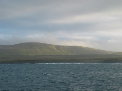
We came here to install a water temperature meter on a pier on the other side of the island. But the swell was too strong for a small boat to land on shore. We sat here on the north side of the island twice during the trip to hide from a storm that was lashing the south side of the island and the waters to the south.

Sun-lit hills on St. George. We sat here, off shore, twice during the trip to hide from severe south winds and swell.
A few photos to show how moorings are put together, deployed and recovered.

To keep the mooring from floating to the surface it must be anchored. 2-4 rail car wheels are used for that purpose, depending on how many instruments are deployed.

The anchor goes in first and then the release (yellow tubular instrument) is just above it. When the mooring is recovered a radio signal is sent to the release and the hook attached to the chain lets go. The release is recovered with the rest of the instruments as it is an expensive piece of equipment.

Here are lengths of chain with instruments attached, strung out on the deck and awaiting deployment. Instruments on these moorings are measuring sea temperature, fluorine concentration, nitrate concentration, and salinity at different depths. The yellow steel buoys are placed along the length of the mooring to keep the mooring line/chain taught and in as straight of a line as possible. The buoys also bring the instruments to the surface when the release mechanism lets go of the anchor. Two buoys are placed at the top of the mooring and are the ones seen when the mooring is released.

A section of chain and instruments are hoisted up with one reel line. The other reel line is attached to the chain holding the anchor over the end of the ship. Once the hoisted section of chain is attached it is raised enough to take all the weight off the line holding up the anchor so that line can be taken off and used to hoist up the next section of chain and instruments.

Here are the two reels used to reel in/out the line attached to the mooring chain.

The cage to the far right has an instrument I came on this cruise to deploy. 4 of these nitrate concentration analysers were deployed at 3 different sites. 3 were also recovered from 3 of those sites. 2 of these sites will be visited in March, 2008 for recovery of the instruments and deployment of ones that have been re-calibrated and have a new battery. One instrument will stay in for a year because sea-ice will prevent us from getting to it in the spring.

Pictures of a mooring recovery.
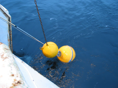
Once the mooring is released, the officers on the ship's bridge look for the floating buoys. The ship then sails near the buoy's. Reel line is held over the side of the ship with a crane. Once the buoys pass by the line, it is released from the end of the crane and the buoys are caught when the line cinches tight.
 Reeling in the mooring.
 Bringing up the top buoys.
The method of recovery is the same as the deployment, only backwards; a section is brought up with one reel, the other reel line is attached to a section below, the first section is lowered to take the tension off and that section is taken off the mooring line/chain, the next section is brought up by the other reel, etc.......
The work is pretty smooth in calm waters. Things got a little interesting when we had 12 foot swells bobbing the back end of the ship up and down and swinging the mooring line back and forth. Up to 4 tag lines would be used then to try and keep the mooring line and the instruments under control.
 A surface mooring had to be taken in on this trip. They are only used in the summer months because sea-ice would rip this buoy off the mooring line if left in over winter. The subsurface moorings must be below the sea-ice so as to be safe from getting damaged from the sea-ice. Thus the top of the mooring is usually 20 meters below the surface.
Some instruments on top of the surface buoy had to be taken off so they would not be damaged when taken aboard. One of the NOAA officers did this task because the technician that would normally do it got very sick last time and asked for volunteers! In these swells the buoy was moving all over the place.

Hanging out on the buoy
 Surface buoy on board. A string of instruments were down below it, just like on other moorings.


2 comments:
Dan--great post from you trip out to the Bering Sea. Blog looks good!
In 1992 we were doing damage control on the Yard Arm Knot, anchored off St George, after getting hit by a japanese tramp freezer ship that was eager to get alongside. There is no beach to run it aground on there, so we had to plug the leaks until Magone divers got there and splash zoned the outside of the 15' diameter crack/dent in the port side. KL
Post a Comment